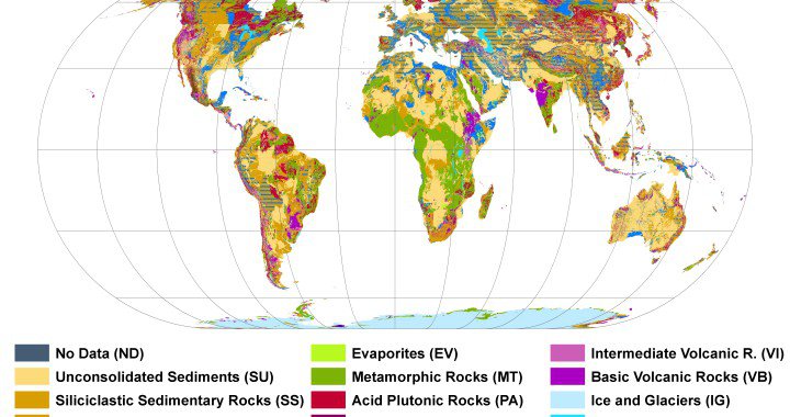
It’s colorful, it’s huge and it’s a hundred times more detailed than its predecessors.
It’s a new lithological map of the world![]() Hartmann, J., & Moosdorf, N. (2012). The new global lithological map database GLiM: A representation of rock properties at the Earth surface Geochemistry Geophysics Geosystems, 13 DOI: 10.1029/2012GC004370.
Hartmann, J., & Moosdorf, N. (2012). The new global lithological map database GLiM: A representation of rock properties at the Earth surface Geochemistry Geophysics Geosystems, 13 DOI: 10.1029/2012GC004370.
The map is a huge puzzle made out of over 75 regional maps from over 300 sources containing regional geological inf-oration. However, this patchwork of geological information had two tricky parts.
”For the map, we combined the characteristics of the bedrock in different regions, like piecing together a large puzzle,” says Nils Moordorf.
”We standardized the nomenclature of the rock types globally and eliminated contradictions as well as blind spots?.
There are some spots on Earth that aren’t covered by regional maps, these had to be handled accordingly to provide a global map. Another problem is contradicting information. Inconsistencies at borders of countries led to inconsistencies in the geological information so that these had to be resolved. Additionally the sources contain different naming conventions, just like kilogram and pound there are different naming conventions for different bedrock types. Working with this load of data is really some kind of puzzle.

Now that we have this kind of information, there are quite a few possible applications.
Geology is what surrounds us – the ground we stand on;
so how can we benefit from this data?
Georisks
It’s pretty simple: Different bedrock has different properties and different applications for different regions.
The most evident use are georisks and I would like to pick out two at this stage. There has been some news reporting about sink holes. These sinkholes can be of impressive size and are usually a danger to the lives of people. Entire houses drop into the ground that used to be stable. This phenomenon can happen if the geological soil below the soil you build on gets eroded. There are some regions that can be especially prone to this weathering: Lime stone and salt domesWikipedia – Karst. They are soluble and ground water might leave huge cave systems where salt used to support the ground. These systems are called Karst and can be very beautiful but just imagine where all that water comes out of the rock and how many caves must be incised into the seemingly hard rock.
Landslides

Another example that becomes more and more important with growing populations are landslides. They are not very well understood and can be triggered from a diverse spectrum of causesLandslide Blog. However, we can identify a couple of risk factors. One of these factors can be that sediments are lying on top of a layer that is impermeable to water. This way rainfall can gather at the bottom of the sediment on top of the impermeable layer and eventually function as a lubricant for the overlying sediment.
Natural Resources and Sustainability
But we can apply this research in other fields as well. In terms of natural resources this map can give indicators for the long-term availability of silicon, phosphor and possibly other resources. These serve as nutrients in the ecosystem but are also important resources that can be used for exploration. As we’re already looking into the storage capabilities of the ground, we might as well point to the ground being a carbon storage. This research is applied but isn’t limited to climate research as carbon and organic matter in general are important in many processes and coupling mechanisms.
Groundwater
This new map has already been used with respect to groundwater. When we drill a well for groundwater supply, we need a property of the reservoir rock called permeability. This basically indicates how well ground water flows through certain rock. This is what researcher had a close look at, they used these rock properties from the global lithological map and obtained the global groundwater permeabilityGleeson, T., Smith, L., Moosdorf, N., Hartmann, J., D?rr, H., Manning, A., van Beek, L., & Jellinek, A. (2011). Mapping permeability over the surface of the Earth Geophysical Research Letters, 38 (2) DOI: 10.1029/2010GL045565. This might just be the tool to improve planning of wells, where fresh drinking water is still scarce.
The data of the map is published on Pangea under the Creative Commons license and contains three layers of lithological information and its combinations with subclasses. I’m particularly proud to present this kind of research since it is from my universityGLiM – Global Lithological Map Project and additionally the usage license is open for use.
Jesper Dramsch
Latest posts by Jesper Dramsch (see all)
- Juneteenth 2020 - 2020-06-19
- All About Dashboards – Friday Faves - 2020-05-22
- Keeping Busy – Friday Faves - 2020-04-24
A Global Lithological #Map. http://t.co/5lgPshO7 via @JesperDramsch #Geology
Nice post Jesper and nice to know. This is a great map to have.
A comment on landslides and risk: with how things go today (e.g. L’Aquila trial) are geoscientists going to take the responsibility of “predicting” landslides?
Hey Matteo,
Thanks for the feedback.
I think in terms of geohazards we always have to be careful with predictions. Landslides are about as poorly understood as seismic hazards, however it is possible to make some assessments on how safe it is open build at some place.
This semester I attend a lecture on Engineering geology where werden learn to make proper risk assessments. It’s quite intiminidating what you have to take into account to secure a building site.
Geoscientists and geoengineers will always be involved in this evaluation, since we’re the only people who have the proper knowledge, as limited as it may be.
What is your take on this?
Wow! https://t.co/Xky0h5WPUU